Defining a Location
Post Code
There are a number of ways of specifying the
location of a particular place. The most obvious
is the full postal address, although these days,
giving just your Post Code and house number, is
sufficient for a trader to find your full
address from a readily available database.
Here we are at:
OX10 6LA
LAT/LONG
This is perfectly fine for a postman, or if you
happen to have a large scale map showing street
names. However, to find a location in the world
or within a particular country, you need to use
a different method of reference. Historically
and traditionally, the world is divided up using
lines of LATITUDE and LONGITUDE. Latitude is
used to specify a position North or South of the
Equator and Longitude specifies a position East
or West of the Meridian, which happens to pass
through Greenwich in London. Since the Earth
rotates approximately once in every 24 hours and
there are 360 degrees in a circle (derived from
the approximate number of days for the Earth to
circle the Sun in a year, and where 360 can be
divided by so many other whole numbers), the
imaginary lines of Longitude have been divided
up into 360 parts, or 180 degrees to the East
and 180 degrees to the West of the Greenwich
meridian at 0 degrees. Stating a distance
between lines of 1 degree is not easy, since at
the Equator, this is about 70 miles, because the
circumference is some 25,000 miles (meaning the
Earth rotates at just over 1000 mph), but as you
move towards either of the poles, this
diminishes towards zero. However, in all
positions, it takes 1 hour to rotate 15 degrees,
or to put it in an astronomical way, the Sun
(and stars) seem to move an angle of 15 degrees
across the sky every hour. Using degrees alone
is not sufficient to identify a particular spot
on Earth, so degrees are sub-divided into 60
parts called minutes of arc and these are
further divided (not surprisingly) into 60
seconds of arc. This means that the distance of
70 miles between degrees of longitude at the
equator can be reduced to about 0.02 miles
between seconds, a much more useful distance in
terms of referencing a point. Longitude is
obviously useless on its own, since this
specifies any position on a line which encircles
the earth. Latitude lines are therefore used to
complete a grid reference, where the angular
measurements using degrees (still about 70 miles
apart throughout), are again sub-divided into
minutes and seconds of arc.
Global Position
This method of referencing a particular point on
earth is used in Atlases, marine and
aeronautical charts. Originally devised by
taking accurate measurements of time, angular
position of the sun and the angular position of
known landmarks, such global positioning can now
be derived from 24 satellites positioned
some 12,000 miles above the Earth. Known as a
Global Positioning System (GPS), these
satellites were originally launched by the USA
and used for military purposes. For many years
however, the signals have also been available to
anyone with a GPS receiver, to determine
position, height, speed etc. It is envisaged
that the Russian and European Space Agencies
will also provide their own systems in the
future. GPS receivers are available separately
(approx. £100) or integrated into navigational
systems in ships, aircraft, weapons and more
recently, in cars. Such separate units will give
basic indications of position in terms of
providing a Lat/Long reference, but if plugged
into a PC or PDA (Personal Digital Assistant)
running some kind of mapping or navigational
software, will provide full colour maps showing
you your current position. Some even speak to
you, to direct you to a particular predefined
destination. Using one such device, our global
position is found to be:
Latitude: 51º 37' 22'' (51.623º) N
Longitude: 1º 04' 38'' (1.077º) W
Grid Reference
In many respects, this method of positional
reference is a little complex when using a more
local mapping system. As far as the British
Ordnance Survey, Great Britain is divided up
into a grid of squares measuring 100 kilometres
by 100 kilometres, each identified by two
letters. Each square is further divided up into
squares measuring 10 km by 10 km. Each of these
can then be divided up, and so on.
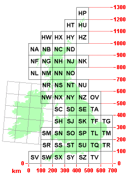
The origin of the grid occurs at a point some 70 Km west of the Scilly Isles at an Ordnance Survey reference of SV000000. Ewelme falls within the SU Grid. It is then a matter of determining the distance of the location from its South West origin Eastwards (easting) to coordinate with the distance of the location Northwards (northing). The Ordnance Survey Reference (O.S) for Ewelme is:
SU639920
This basically means we are 63.9 Km East and 92.0 Km North from the origin of the SU grid (Wimbourne, Dorset). Another way to describe the reference, is to use the origin of the grid point off the Isles of Scilly, and define purely numerical eastings and northings as two groups of more precise numbers. Therefore, the GB Grid Ref of where we live is:
463986, 192000
This is the equivalent of describing that we are 463.986 Km East and 192.0 Km North from a specific point off Scilly.
Mountain or Hill
Having a GPS system can also determine one's
elevation or height above a mean sea level. The
elevation at the entrance to our house is:
251 feet, 76.5 metres
More information can be found about GPS systems by clicking here.
Find out more about Navigation Software from here.
To visit the Ordnance Survey site click here.